


If you are lucky as I was to land on the island of Lanzarote with the daylight, the first thing that will strike you will be the incredible landscape – an outer planet one.
A deep red soil that fades into blackness, pure white houses with green or blue shutters, tall and skinny green palm trees, and a crystal blue sea all around.
We cannot be on planet Earth anymore.
Lanzarote is a volcanic island, which is why it is also called “La Isla del Fuego” (the fire’s island). It is almost entirely covered with solidified lava, which depending on the sunlight, takes various colors: from red to black to ocher.
The preservation of the breathtaking natural environment is the government’s priority: declared by UNESCO “World Biosphere Reserve” in 1993, 43% of the island’s territory is bound by prohibitions to preserve its beauty and safeguard flora and fauna. That’s why all the houses are white and with shutters painted brown, green or blue.
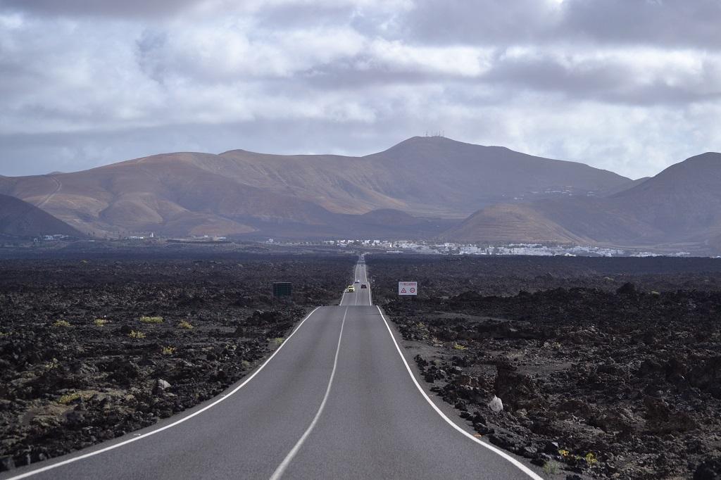
The attention to nature doesn’t come at the expense of tourism: Lanzarote offers great facilities, plenty of activities to do, and one of the best-paved roads I’ve ever seen.
There’s nothing better than exploring the island riding (or driving).
Day 1: Arrecife – around and about [25,2 km]
The only airport of Lanzarote is located in its capital city, Arrecife. Because of its position, Arrecife is the best place to base yourself.
Get off of the aircraft, rent your bike or car directly at the airport, and make your way to explore the Isla del Fuego.
I spent a whole week in Lanzarote with my sister and two of our friends. Once we checked into the Airbnb we rented in the city center, we hit the road immediately, too fascinated by the view of the landscape we had from the airplane to resist!
Following the LZ-301 towards the inner part of the island, one thing struck us: the smoothness of the roads. It’s a pleasure to go from one location to the other! After a 15-minute drive, we reach Las Grietas, a little walkable canyon facing the Atlantic Ocean.
I suggest visiting it at mid-day when the sun is at its zenith and illuminates the rocks of the canyon to donate them a gorgeous pearl gray color!
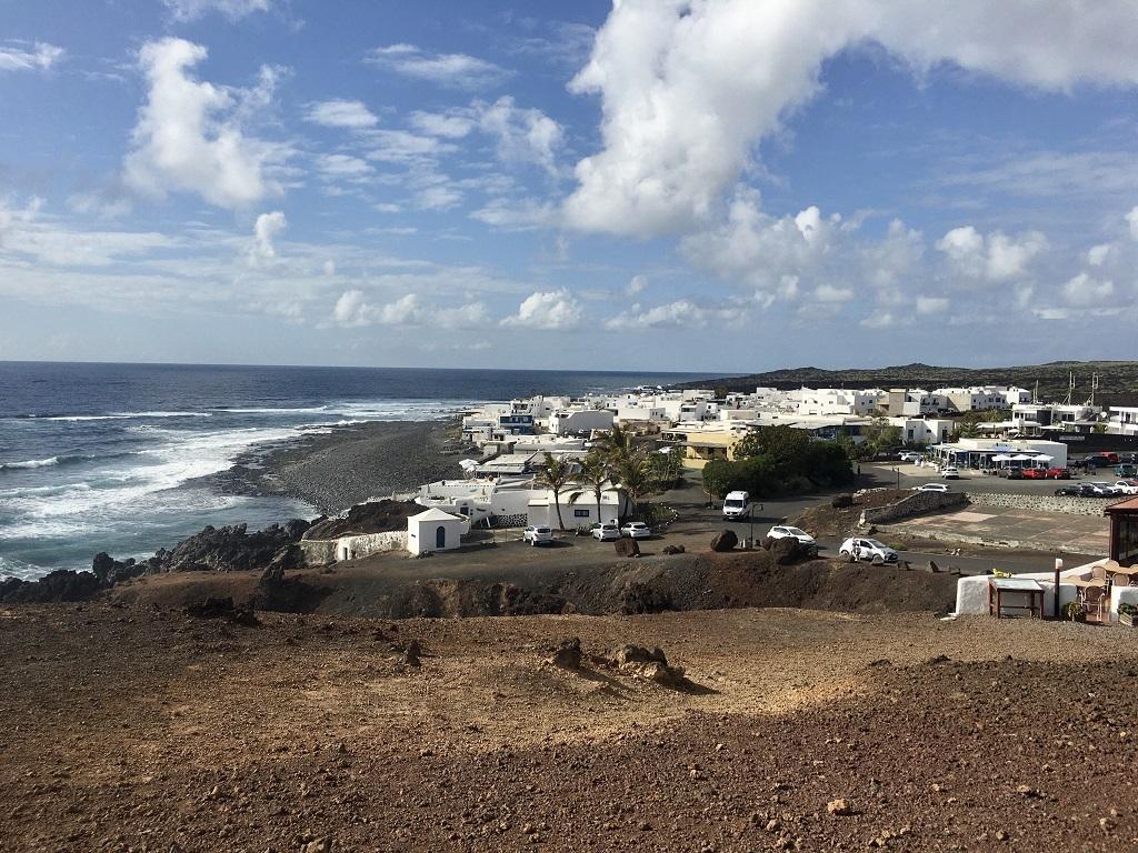
After taking some photos, we took the long road back to Arrecife, going through the small town of Tìas and then along the coast (LZ-2).
Once in Arrecife, we parked and began to explore the capital of Lanzarote on foot. We decided to remain in the promenade area: after a break at the main beach, Playa del Reducto, we walked and reached the Castillo de San Gabriel. The small castle is situated on the Isle de Los Ingles, accessible by two walkways that connect it to the mainland. The passage is really scenographic, and there is also a small beach next to the castle where you can sit and chill out after visiting. In fact, inside the castle, there is a museum that looks at the ethnographic history of Lanzarote.
The promenade is full of bars, cafes, and restaurants: after the first cerveza (beer) of our trip, we returned to our apartment to rest and be ready for day 2 of our week in Lanzarote.
Day 2: exploring the north of the Island [87,9 km]
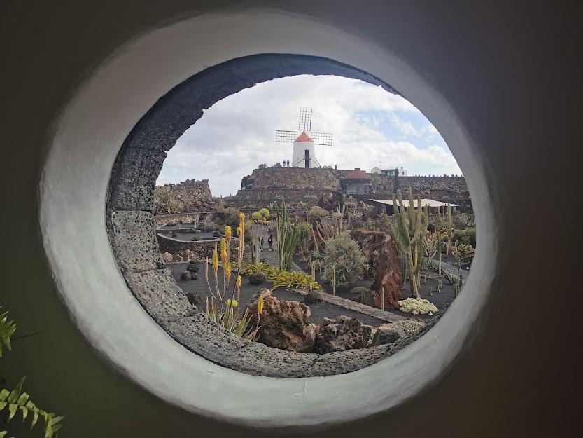
Waking up bright and early, and after having packed lunch, we took the LZ-1 to the north of Lanzarote. In 20 minutes, we arrived at the Jardín de Cactus (Cactus Garden), one of the magnificent works of artist César Manrique. The combination of art and nature, with the architecture integrated into the landscape, is the signature of César Manrique’s works.
Proceeding north through the LZ-1 will lead you to the Jameos del Agua and the Cuevas de los Verdes, both gorgeous volcanic places that Manrique was able to make even more special.
Back to the road, we planned to reach the Volcan de la Corona and do a picnic before hiking. But the coast up to the north is stunning, and there are plenty of coves to stop by.
So we decided to stop along the Avenida del Caletón and rest and have lunch on the beach. That day was super windy, but we found a spot with lava walls constructed in such a way to create tiny “halls” to hide inside and find shelter from the wind. Super cool and handy!
After lunch, we left the LZ-1 and turned onto the LZ-203 to arrive at the Volcan de la Corona. We passed the volcano on its eastern side until we reached a crossroads on the right, at the entrance of the town of Ye.
We parked in front of the little church of Ye: the path to start the trekking is nearby the church, and to reach the suggestive top of the volcano, you will need to walk for 3 km.
When we descended, it was late afternoon. It was time for a beer and some tapas. The LZ-1 accompanied us to the gorgeous coastal town of Orzola, where the ferries for the island La Graciosa depart.
The tiny promenade has many restaurants and bars to have something to eat and drink: we stopped at the characteristic “Restaurante Os Gallegos” where we have some great tapas – pan y tomate and the papas arrugadas (potatoes), Canary Islands’ national dish.
It was then time to go back to Arrecife.
Day 3: living the Isla del Fuego [74,2 km]
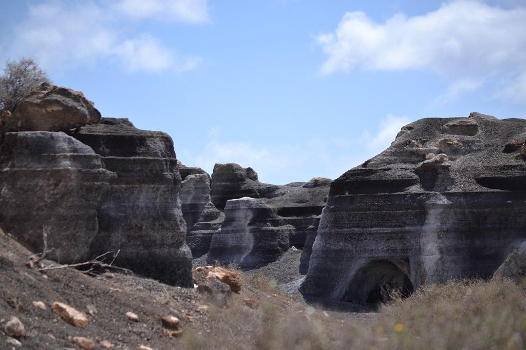
Another day, another early bird wake! Quick breakfast, some lunch packing, and we took again the LZ-1 to go and visit the Antigua rofera de Teseguite, one of the unique rock formations in Lanzarote.
Also known in English as Stratified City, this is a series of leftover volcanic rocks that have been shaped by wind, rain, and sun over thousands of years. This strange rocky “city” is super fascinating: several weird holes, tunnels, and caves have been created in the massif. Walking around and on top of these formations is an otherwordly experience!
Less than 10 minutes away from the Stratified City, there is the town of Teguise, the ancient capital city of Lanzarote. The beautiful center is the ideal place to breathe the authentic spirit of the island.
After wandering around Teguise for a while, we hit the road again, this time to the west of Lanzarote. It was time to visit the Timanfaya National Park, one of the most incredible places on the island.
The Park is 51 square km, and the scenery has been designated a biosphere reserve by UNESCO. Only one active volcano is inside the Timanfaya National Park, and the greatest recorded eruptions happened between 1730 and 1736. The landscape of the Timanfaya is truly Martian!
The only thing is that you cannot just rock up to the park and walk-in. It can only be explored by tour: there is a hiking tour option that is more expensive and must be booked way in advance. We opted for the more classic bus tour through the park: it was pretty incredible, but if you have the chance go for the hike!
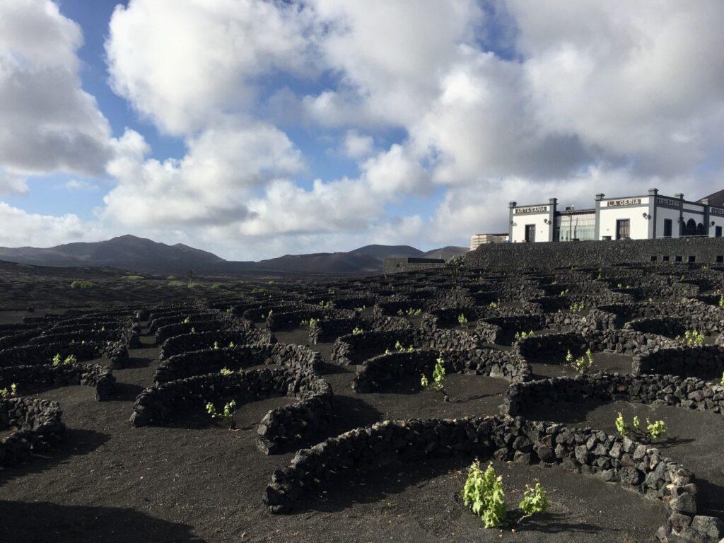
The afternoon led us to La Geria, the wine valley of Lanzarote. The soil in Lanzarote is not easy to cultivate. Still, the people living there managed to find a way: plants are cultivated inside circles made of lava rocks. The all-black landscape sprinkled with the lush green of the plants is a true spectacle!
The other reason to visit the wine valley is… well, the wine! The process used to grow the grapes gives the wine a special taste. Seventy-five percent of the wines are made from the Malvasia grape, and this is exactly the wine that delighted us during our aperitivo at Bodega La Geria, the historic family-run winery.
After a beautiful sunset walk around the crops, we returned to Arrecife.
Day 4: making our way to the west [73,7 km]
We woke up with clouds shading the sky, but we had planned to hike La Caldera Blanca, one of the volcanos in the Parque Natural de Los Volcanes. So we got ready (with lunch and lots of water), and after a 40-minutes drive to the west of Lanzarote, we began the hike.
The place is absolutely stunning: the black landscape of solidified lava is broken by the hill-tall, okra, volcanos. Arriving at the top of La Caldera Blanca is easy, and the view is magical.
We decided to descend on the other side of the volcano – as the majority of the people there – which turned out not to be the best move: the soil is rather slippery and sloped, and without proper trekking shoes going down is not fun!
We managed to reach the bottom of the volcano – after a long while because we were going slowly – and we could finally have a well-deserved lunch.
The sky is now clear, and the sun shines above our heads. It was time to explore Lanzarote’s west coast. Driving on the LZ-67 and then the LZ-704 for 30-ish minutes is everything that took us to arrive at the coastal town of El Golfo.
We parked and grabbed a coffee in one of the several cafes. With caffeine waking us up, we walked to reach the Charco de Los Clicos, a green lake surrounded by reddish soil. The blue sea and white houses make the scenario breathtaking.
Many photos and videos later, we took a rest in the Playa el Golfo.
It was then time to go back, but not before having stopped in Yaiza. We wander around for a while, admiring the Lanzarotian character of the town, among white-painted houses, art galleries, and tapas bar.
The fourth day of our trip was full of wonders. Finally, pretty tired, we went back to Arrecife.
Day 5: A day for the southern sea [82,1 km]
The day started with the sun shining and the temperature being warm – and with no wind, for once. The weather meant only one thing for us: going to the beach.
We started by exploring one of the two most famous beaches of Lanzarote: Playa de Papagayo. The entrance costs 3€ (free in the later afternoon) because it is part of the naturalistic park Los Ajaches. Arriving at the beach is an adventure in itself: the 4 km long road is super bumpy – not the best for two-wheel lovers!
The stunning Playa de Papagayo is usually very crowded: after a couple of hours, we decided to leave and try another beach. In 20 minutes, we arrived at Playa Dorada, with crystal clear waters and several services.
Part of this beach is reserved for hotel residents, thus you will find umbrellas and seats on the sand. Nonetheless, the site is tranquil, and there are several cafes to grab something to eat and drink.
For lunch, we moved to the near Playa Blanca, a 10-minutes walk from Playa Dorada. The beach is quite small and nearby the port from where sail the ferries for the other Canary Islands.
Fuerteventura is so close that it is possible to see the island by being on the beach! Having ferries coming and going to the port creates interesting situations: sudden and quite high waves… you literally need to escape from the sandy beach if you don’t want to get soaking wet!
Playa Blanca’s promenade (also the name of the town) is packed with restaurants and cafes. After lunch, my sister had reserved a visit to the Atlantic Museum, the first underwater museum of the Atlantic Ocean and Europe.
The sculptures are located about 12 meters deep and cover an area of 2,500 square meters. So yeah, you need to dive to visit the museum! We dropped my sister off, and we went back to Playa Blanca to sunbathe – guess who’s the most adventurous of the group!
The Atlantic Museum is an amazing experience that everyone can do – you don’t need to be a certified scuba diver.

We enjoyed Playa Blanca so much that we decided to remain for dinner. The choice was special: a restaurant/tapas place that hadn’t aged a second since the 1980s! I mean, what’s better than prawn cocktails?
A night walk in Playa Blanca and the returning to Arrecife put an end to day 5.
Day 6: [68,4 km]
The holiday is coming to an end, but there are still lots of places we would like to visit. This is why day 6 and day 7 of the trip are a little hectic!
In the morning, we drove the LZ-20 to go to San Bartolomè. Walking through the town’s streets is a journey back to the past: here, there is the last remaining working windmill of Lanzarote. The wind is a fundamental energetic resource for the island, and there are wind turbines everywhere you go.
After San Bartolomè we drove up north to the other famous beach of Lanzarote (with Playa de Papagayo): Playa de Famara. This is the best spot to surf and kitesurf because it’s always super windy, and the waves are perfect if you enjoy water sports.
There are numerous surf schools directly on the beach where you can go and give surfing a try. Unfortunately, the weather was not on our side that day: way too much wind – it was almost cold!
When it started raining, we decided to leave the beach – which it’s gorgeous with its white sandy dunes – to see and drive the street known for resembling the American Route 66. Once arrive in the small town of Soo, go down the LZ-401 and let the road leave you speechless!
A million photos later, we headed south to Puerto del Carmen, the main tourist spot of Lanzarote… and the island’s nightlife! We had dinner there, and it was (finally) time to go clubbing.
While the night was fading into daylight, we went back to the apartment in Arrecife to sleep and be ready for our last day on the Isla del Fuego.
Day 7: What’s left to see – and back to Italy [124 km]
The morning was busy: breakfast, packing our stuff, and leaving the apartment. There was no time to waste on this last day in Lanzarote. Our flight was at 8:30 pm, but the island had more surprises for us to uncover.
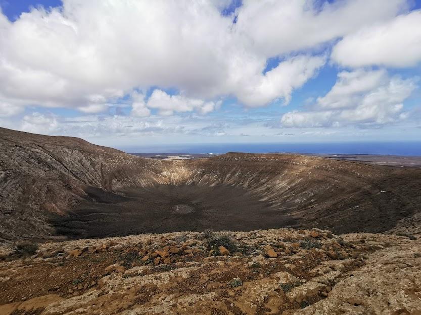
Two hikes made the rest of our morning: the ones at La Montaña Colorada and at Caldera de Los Cuervos – both part of the Los vulcanes National Park.
After lunch, we went to the north of the island: the Mirador del Rio is one of the most scenographic panoramic points in Lanzarote, from where it’s possible to admire the super close island of La Graciosa.
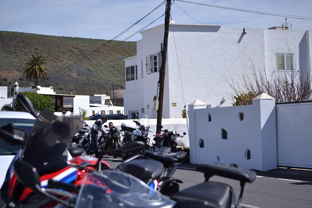
Our next stop was the visit to the town of Haria. White houses and hundreds of palm trees nestled in the mountain chain Risco de Famara makes Haria one of the most beautiful villages in Lanzarote. Here, we run into a motorcycle gathering!
With the sun going down, we began to look for a spot to see the sunset. The search was soon over: nearby Haria, on Calle el Rincón, we found an unpaved road leading to the top of a cliff. The bumpy trail reminded us of the journey to arrive at Playa de Papagayo, although this time was much shorter. The view of the sun setting on the Atlantic ocean was worth the road.
With the image of the sunset, we drove to the airport to leave – for now – the wonderful Isla del Fuego.
Amaizing